South Cape (South Cape CRA / Downtown)
Best for
Walkable nightlife, gastropubs, live music, and trolley crawls
 AdventriaLocalOpen App
DECISION GUIDE
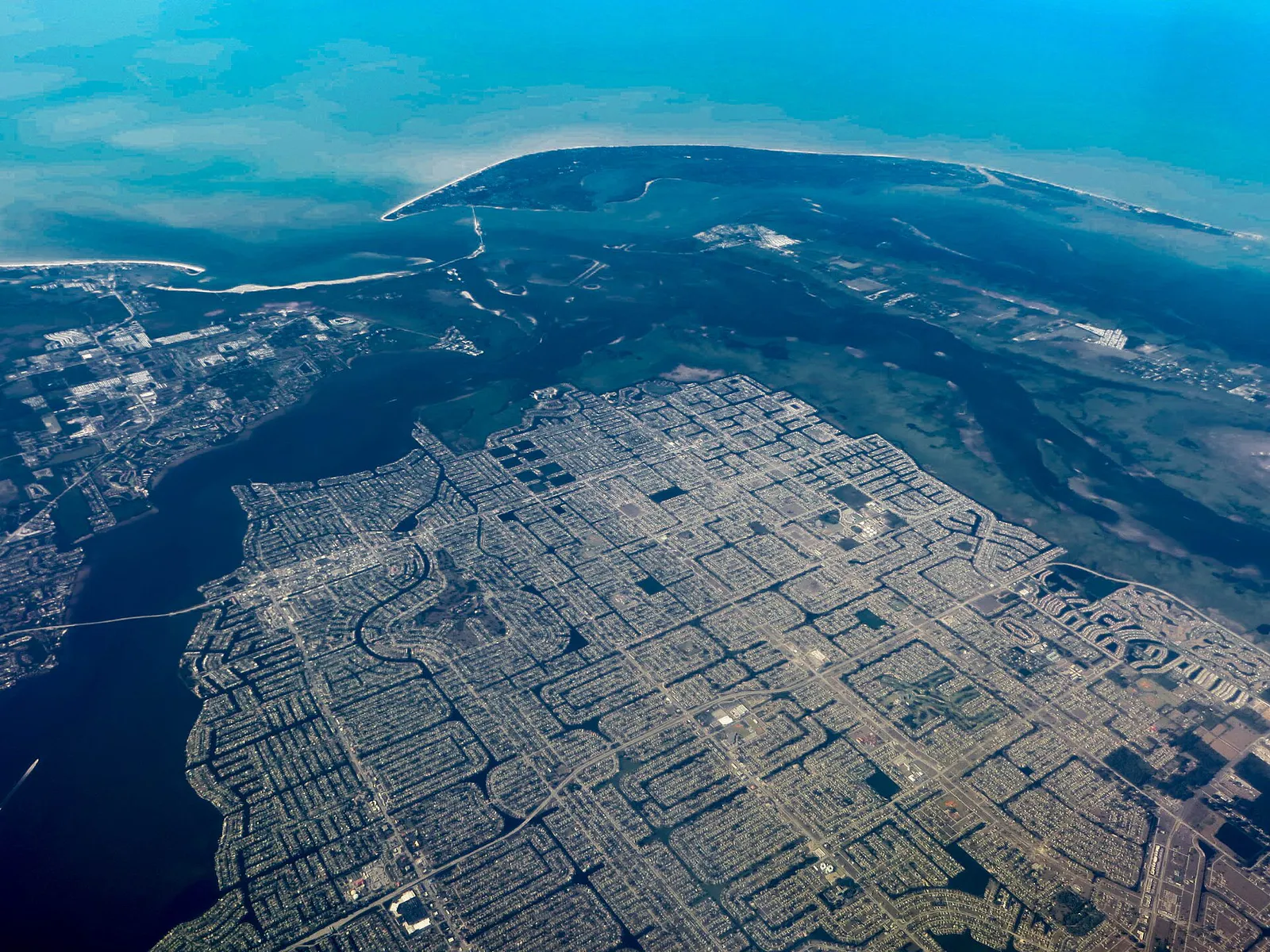
Trying to decide what to do in Cape Coral? Adventria helps you cut through the options and choose a good-enough plan without endless scrolling. Cape Coral spans over 120 square miles with more than 400 miles of man-made canals. Because the city's dense water network limits cross-town cut-throughs, choosing where to eat, explore, or launch a boat requires understanding local quadrant logic, canal bridge clearances, and bridge commute timing into Fort Myers.
The local decision problem
How to navigate Cape Coral's 400 miles of canals, grid travel friction, toll bridge choke points, and distinct waterfront versus inland entertainment nodes to plan daily activities, dining, and outings.
That is where Adventria comes in. Adventria helps narrow the options in Cape Coral around practical factors like location, distance, budget, vibe, who you are with, and the kind of experience you actually want, so research can turn into a decision.
Let Adventria narrow the optionsPick the right part of town
Different parts of Cape Coral work for different kinds of plans. Start with the experience you want, then narrow the map.
Best for
Walkable nightlife, gastropubs, live music, and trolley crawls
Best for
Upscale marina dining, boat watching, and promenade strolls
Best for
Resort-style waterfront dining, sunset views, and hotel stays
Best for
Historic neighborhood charm, river views, and direct boat access
Best for
Eco-park access, quiet suburban streets, and spreader canal boating
Best for
Family activities, public parks, and neighborhood convenience
This is a quick starting point. The full guide covers 8 local neighborhoods and districts in Cape Coral.
Eat & drink
When the decision is less about what to do and more about where to eat or grab a drink, start here. These local cues narrow the food and drink decision without turning dinner or a night out into another hour of comparison.
Head to SE 47th Terrace in South Cape. Parking in public lots behind the strip is free and ample. Walk the block to grab casual seafood at Fish Tale Grill by Merrick Seafood, wood-fired pizza at Oak & Stone, or drinks at Hooked Island Grill and Monkey Bar. Seats open up frequently along the patio bars, and no advance planning is required.
For upscale romantic dining directly on the water, head to Cape Harbour or Tarpon Point. Book outdoor seating at Rumrunners or Marker 92 Waterfront Bar & Bistro to watch luxury yachts navigate the channel during sunset. If you prefer a walkable evening moving between craft cocktail bars and dessert spots, choose South Cape along SE 47th Terrace, starting with dinner at Sage on 47th and ending with a self-pour tap wall draft at Oak & Stone.
Still comparing options? Adventria can narrow the choice around budget, distance, vibe, and who you are with.
Decide with AdventriaPlan by situation
Start with the kind of plan you are actually trying to make. These city-specific ideas narrow the choice around who you are with, what you want to spend, the weather, and the kind of outing you want.
During warmer months (March through September), spend the day at Sun Splash Family Waterpark on Santa Barbara Blvd enjoying the lazy river, slide tower, and wave pool. For a lower-cost, educational morning, visit Rotary Park Environmental Center to tour the Tom Allen Memorial Butterfly House and climb the nature observation tower. For high-energy entertainment, Gator Mike’s Family Fun Park offers go-karts, Dino Falls mini-golf, and arcade games.
When summer thunderstorms roll in around 2:00 PM, escape indoors with a guided tour and tasting at Wicked Dolphin Rum Distillery on SW 10th St. Alternatively, explore local history at the Cape Coral Museum of History on Cultural Park Blvd, play indoor arcade games and laser tag at Gator Mike’s, or paint pottery at The Bent Brush studio on SE 47th Terrace.
For an outdoor plan from Cape Coral, compare trails, state parks, national parks within trip range, and scenic drives. Options in the current city guide include Estero Bay Preserve State Park and Cayo Costa State Park.
Cape Coral offers several high-value, low-cost outdoor spaces. Four Mile Cove Ecological Preserve offers free park entry and boardwalk walking through wetland mangroves. Rotary Park Environmental Center provides free access to native plant gardens, birdwatching trails, and the butterfly house. End the day watching the sunset over the Caloosahatchee River from public shoreline parks in the Yacht Club or SE riverfront area.
Start early with a peaceful walk along the 6,600-foot elevated wooden boardwalk through the mangroves at Four Mile Cove Ecological Preserve. If you enjoy cycling, bring your bike to ride along Del Prado Linear Park or tackle portions of the city’s 49-mile perimeter bike route. In the late afternoon, bring a camera to Sirenia Vista Park in NW Cape Coral to watch for manatees along the quiet canal banks.
For large groups seeking a relaxed atmosphere, reserve a patio area at Cape Harbour's Fathoms or grab outdoor tables at Oak & Stone in South Cape. If visiting during a weekend event, purchase tickets for a South Cape Entertainment Association Trolley Event, which transports groups between neighborhood bars with themed drinks and appetizer tastings.
For a short escape from Cape Coral, compare Naples and Venice. More options are listed in the trip section below.
Outdoors nearby
Use these nearby outdoor options when the plan calls for a trail, protected landscape, park, or drive instead of another indoor stop. Proximity here is geographic, not a promise about driving time.
Get out of town
When staying in town is not the answer, these nearby destinations give you a smaller starting set for a day trip, overnight escape, or weekend away.
Destination relationships are screened geographically. Straight-line proximity is not presented as road mileage or estimated travel time.
Local landmarks & attractions
These notable destinations offer a starting point when you want something specific to see, visit, or build into a day around Cape Coral. Distances are approximate from the city area.
historical museum in Fort Myers, Florida, USA
multi-purpose arena in Estero, Florida, United States
historic district in Fort Myers, Florida, USA
historic district located at Fort Myers, Florida, USA
athletics facility at Florida Gulf Coast University donated by
Notable places are selected from structured public destination data and ranked for relevance, prominence, proximity, and variety.
Local decision signals
A useful local recommendation depends on how the city actually works. These conditions affect where to go, what to do, and whether a plan makes sense right now.
Over 400 miles of canals prevent direct cross-block driving, forcing travel back to major arterials like Pine Island Road, Del Prado Boulevard, Santa Barbara Boulevard, and Veterans Parkway.
Avenues, Boulevards, Courts, and Places run North-South. Streets, Lanes, Terraces, and Parkways run East-West. Santa Barbara splits NW/NE and SW/SE.
Cross-river travel to Fort Myers relies on the Cape Coral Bridge and Midpoint Memorial Bridge, experiencing heavy commute delay from 7:00–9:00 AM eastbound and 4:30–6:30 PM westbound.
June through October brings near-daily afternoon thunderstorms between 2:00 PM and 5:00 PM, making early mornings ideal for outdoor water sports and eco-tours.
Canals range from direct sailboat saltwater access (no fixed bridges) to freshwater landlocked systems with zero Gulf connectivity.
Free surface parking is ubiquitous across commercial plazas, but true walkability is confined to specific pockets like SE 47th Terrace, Cape Harbour Promenade, and Tarpon Point Marina.
Attractions operate on strict seasonal schedules, such as Sun Splash Waterpark (March–September) and Four Mile Cove kayak rentals (November–May).
Neighborhood context
Neighborhoods are not interchangeable. Each area offers a different balance of atmosphere, transportation, food, nightlife, activities, and planning friction.
Best for: Walkable nightlife, gastropubs, live music, and trolley crawls
Centered around Cape Coral Parkway and SE 47th Terrace, South Cape is the city's pedestrian-friendly entertainment core, packing dozens of bars, independent restaurants, and event venues into a walkable grid.
Best for: Upscale marina dining, boat watching, and promenade strolls
A luxury deep-water marina village located at the southern terminus of Chiquita Boulevard in the SW quadrant, featuring high-rise condos, waterfront dining at Rumrunners and Fathoms, and boutique shopping along The Promenade.
Best for: Resort-style waterfront dining, sunset views, and hotel stays
An enclave along Silver King Boulevard anchored by The Westin Cape Coral Resort, offering deep-water marina slips, dockside bars like The Nauti Mermaid, and expansive views over the Caloosahatchee River.
Best for: Historic neighborhood charm, river views, and direct boat access
The city's original platted community from the late 1950s, located along the Caloosahatchee River in the SE quadrant. Known as the Gold Coast, it features mature trees, riverfront parks, and fast open-water boating access.
Best for: Eco-park access, quiet suburban streets, and spreader canal boating
A major residential quadrant in southern Cape Coral bordering the South Spreader Canal. It houses Rotary Park Environmental Center, extensive waterfront homes, and convenient proximity to both South Cape and SW marinas.
Best for: Family activities, public parks, and neighborhood convenience
A central-to-south residential corridor built around local schools and community parks, bridging the gap between SW waterfront nodes and NW expansion zones.
Best for: Nature preserves, manatee watching, kayak launches, and quiet living
A rapidly developing corridor along Burnt Store Road in the NW quadrant. It provides access to nature preserves like Sirenia Vista Park, kayak access to Matlacha Pass, and sprawling residential lots.
Best for: Freshwater lake access, affordable residential living, and shopping plazas
Characterized by vast inland freshwater canal networks and lakes like Lake Kennedy, NE Cape Coral offers suburban quietness, Pine Island Road commercial plazas, and quick land access toward North Fort Myers.
Cape Coral local guide
Choosing where to spend an afternoon or evening in Cape Coral depends heavily on whether you prioritize open-water views or walkable entertainment density. Because the city was built as a vast residential grid punctuated by commercial corridors, entertainment is concentrated into two distinct environments: high-end marina villages and the South Cape CRA downtown strip.
Marina destinations like Cape Harbour and Tarpon Point focus on upscale waterfront ambience. Located at the southern tips of the SW quadrant, these developments offer deep-water boat dockage, scenic views of the Caloosahatchee River, high-rise luxury towers, and polished dining options such as Rumrunners, Fathoms, Marker 92, and High Tide Social House. They are ideal for sunset dinners, boat watching, and relaxed promenade walks, though options outside of the central marina footprint are limited.
In contrast, South Cape (centered along SE 47th Terrace and Cape Coral Parkway) is the city's main pedestrian-friendly commercial center. Here, over 60 gastropubs, live music bars, independent seafood joints, and craft cocktail lounges operate side-by-side. Parking is free across multi-block surface lots, making it easy to park once and hop between spots like Sage on 47th, Fish Tale Grill, and Oak & Stone. Decide on a marina village when you want scenic waterfront dining, and choose South Cape when you want variety and a walkable night out.
Explore your options
Not all of Cape Coral's 400+ miles of canals offer the same water access. Before renting a boat, booking a rental home, or launching a kayak, review how canal categories dictate boating travel.
Unrestricted saltwater routes leading straight to the Caloosahatchee River and Gulf of Mexico without any fixed bridges or locks.
Navigable saltwater canals that eventually reach the Gulf but require passing under bridge overpasses or operating through boat locks.
Linear coastal canals bordering mangrove preserves and aquatic buffer zones along the outer edges of the city.
Inland canal systems connected to internal lakes (such as Lake Kennedy) with zero access to the Gulf of Mexico.
A simpler way to decide
Summer in Southwest Florida brings daily afternoon convective rainstorms. Follow this schedule to build a seamless, weather-smart day.
Complete outdoor physical activities—such as walking the boardwalk at Four Mile Cove Eco Preserve or paddling at Sirenia Vista Park—before heat and storm clouds build up.
Enjoy an early lunch on the covered patio at Cape Harbour or Tarpon Point while skies remain clear and breezes blow off the river.
Head indoors by mid-afternoon as convective rain clouds reliably gather between 2:00 PM and 5:00 PM across Lee County.
Take a tasting tour at Wicked Dolphin Rum Distillery, visit the Cape Coral Museum of History, or head to Gator Mike's for indoor arcade gaming and laser tag while rain pours outside.
As storm cells clear out by late afternoon, head to SE 47th Terrace for dry evening walking, open-air dining, and live music.
Common local questions
These are common situations people face when trying to decide where to eat, what to do, where to get drinks, or how to spend their time in Cape Coral.
Cape Coral planning questions
Practical answers for people deciding where to eat, what to do, where to go, or how to make plans in Cape Coral.
Direct Gulf access canals (saltwater) have no fixed bridges or water control structures between the boat dock and the Caloosahatchee River or Matlacha Pass. Indirect access canals require passing under bridge overpasses with specific height clearances or navigating through water control locks.
Cape Coral is a sprawling city covering over 120 square miles, making automobiles or rideshares the most practical transport. However, localized areas like South Cape (SE 47th Terrace), Cape Harbour, and Tarpon Point are highly walkable once you arrive. The city also offers over 120 miles of multi-use bike paths for cyclists.
Traffic is heaviest during morning peak commute hours (7:00 AM – 9:00 AM) heading eastbound toward Fort Myers across the Cape Coral Bridge and Midpoint Memorial Bridge. Evening peak commute hours (4:30 PM – 6:30 PM) experience severe westbound delays returning into Cape Coral.
Yes. Entry is free at Four Mile Cove Ecological Preserve, which features a 6,600-foot mangrove boardwalk trail, and Rotary Park Environmental Center, which offers native plant gardens, birding trails, and the Tom Allen Memorial Butterfly House.
Top indoor options during the 2:00 PM – 5:00 PM summer rain window include tours at Wicked Dolphin Rum Distillery, museum exhibits at the Cape Coral Museum of History, arcade games at Gator Mike’s, performances at Cultural Park Theatre, and indoor pottery painting at The Bent Brush.
Sirenia Vista Park in Northwest Cape Coral is one of the top spots for viewing manatees, particularly during cooler winter months when manatees seek refuge in warm canal waters. The park features dedicated observation areas and kayak launches.
South Cape (SE quadrant) is the city's historic, urbanized downtown district featuring high restaurant density, nightlife, and quick boat access to the river. Northwest Cape Coral is a lower-density growth area characterized by nature preserves, eco-parks, spreader canals, and new residential developments along the Burnt Store Road corridor.
During peak winter season (January through April), reservations are highly recommended for prime dinner hours at upscale waterfront spots like Rumrunners and Marker 92. Casual venues like Fathoms, High Tide Social House, and The Nauti Mermaid offer first-come, first-served seating at patio bars.
Cape Coral uses the ABC+P system for North-South thoroughfares: Avenues, Boulevards, Courts, and Places run North-South. Streets, Lanes, Terraces, and Parkways run East-West. Santa Barbara Blvd splits the city into West and East, while Hancock Bridge Pkwy / Embers Pkwy split North and South.
Source transparency
Official and locally relevant sources used to verify the practical information presented in this Cape Coral decision guide.
Cape Coral decision engine
Tell Adventria what kind of experience you want, set your practical limits, and turn the options in Cape Coral into one workable plan.
Choose a Cape Coral Plan