Downtown Astoria
Best for
Walkable dining, boutique shopping, and historic cultural sites
 AdventriaLocalOpen App
Oregon Coast & Columbia River Estuary Guide
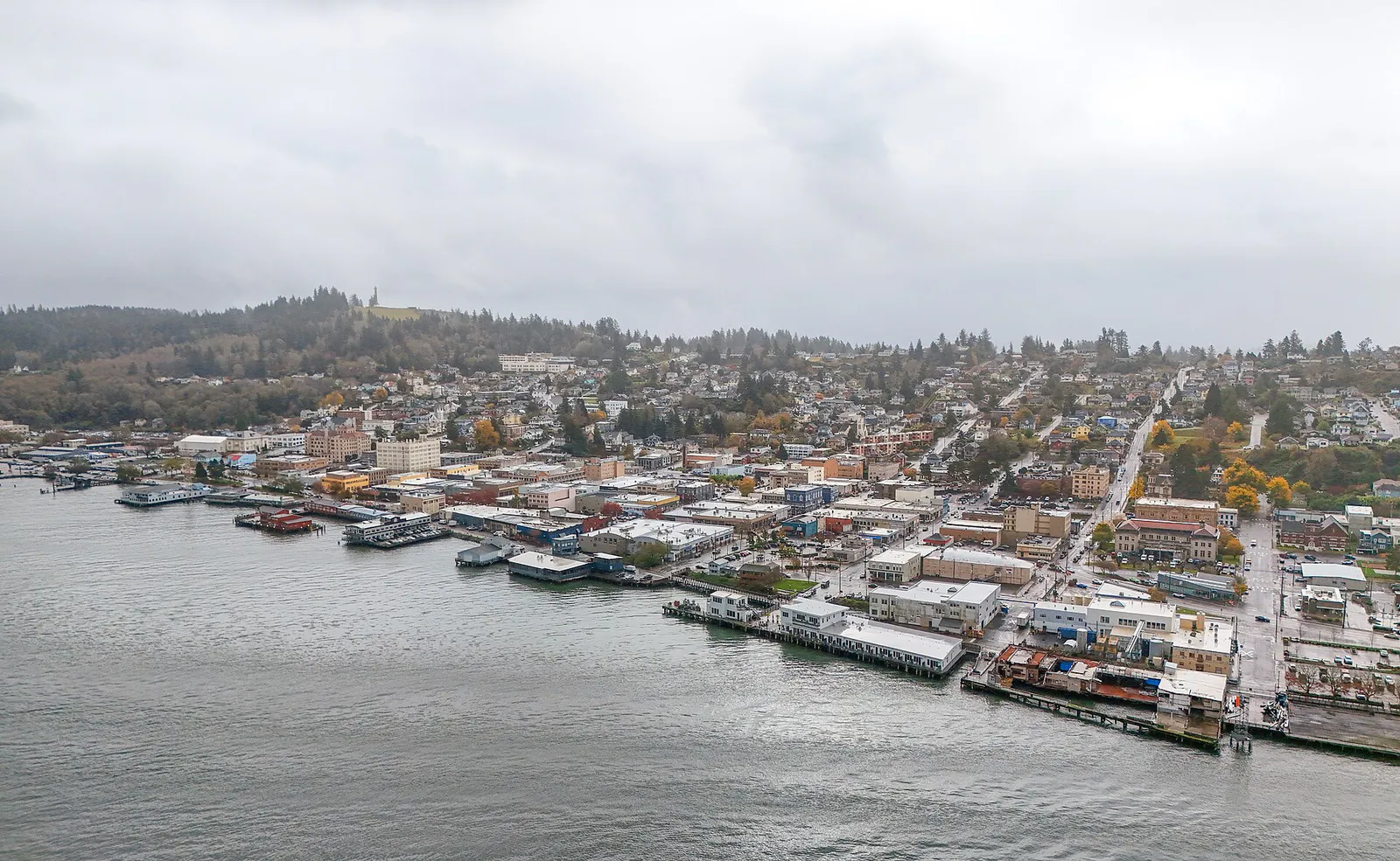
Trying to decide what to do in Astoria? Adventria helps you cut through the options and choose a good-enough plan without endless scrolling. Astoria’s dramatic vertical landscape, historic cannery waterfront, and active shipping channels present unique logistical factors for visitors and residents. From managing weekday parking rules downtown to planning around sudden rain or bridge travel, this guide provides actionable details to help you navigate local options effectively.
The local decision problem
How to navigate Astoria's vertical topography, waterfront logistics, microclimate shifts, and walk-in dining culture across varied trip profiles and seasonal weather patterns.
That is where Adventria comes in. Adventria helps narrow the options in Astoria around practical factors like location, distance, budget, vibe, who you are with, and the kind of experience you actually want, so research can turn into a decision.
Let Adventria narrow the optionsPick the right part of town
Different parts of Astoria work for different kinds of plans. Start with the experience you want, then narrow the map.
Best for
Walkable dining, boutique shopping, and historic cultural sites
Best for
Maritime access, waterfront dining, and lodging near US 101
Best for
Historic cannery landmarks, quiet eastern waterfront, and river views
Best for
Modern residential living and peaceful walking paths
Best for
Panoramic estuary views, Victorian architecture, and stair climbs
Best for
Residential neighborhoods removed from tourist traffic
This is a quick starting point. The full guide covers 7 local neighborhoods and districts in Astoria.
Eat & drink
Trying to decide where to eat in Astoria? Start with the local dining context below and narrow the decision around the kind of meal or experience you actually want.
Head to downtown craft breweries like Fort George Brewery on Duane Street or the Buoy Beer taproom, both of which operate on a first-come, first-served basis. For iconic quick seafood, queue early at Bowpicker Fish & Chips at 17th and Exchange Streets before their daily supply of albacore tuna sells out.
Still comparing options? Adventria can narrow the choice around budget, distance, vibe, and who you are with.
Decide with AdventriaPlan by situation
Start with the kind of plan you are actually trying to make. These city-specific ideas narrow the choice around who you are with, what you want to spend, the weather, and the kind of outing you want.
For an outdoor plan from Astoria, compare trails, state parks, national parks within trip range, and scenic drives. Options in the current city guide include Fort Columbia and Gearheart Ocean State Park.
Stroll the Riverwalk near sunset past active shipping lanes, reserve a table at Bridgewater Bistro near the Astoria–Megler Bridge for views of the river, and sip spirits at Pilot House Distilling or take a Victorian architecture walk downtown.
Buy $1 balsa wood gliders at the Astoria Column gift shop to fly from the observation deck, ride the historic Riverfront Trolley for $1, examine Coast Guard rescue boats at the Maritime Museum, or explore Fort Clatsop.
Spend hours indoors at the 30,000+ square foot Columbia River Maritime Museum, visit the Oregon Film Museum inside the historic Clatsop County Jail, or tour vintage exhibits in the Heritage Museum.
Visit Youngs River Falls for free, purchase a $5 annual vehicle permit to explore Astoria Column park, ride the Astoria Riverfront Trolley for $1 per single ride, or relax in the Garden of Surging Waves downtown.
Gather at Fort George Brewery, which spans a city block with distinct dining rooms, or visit the Buoy Beer taproom complex with its shared courtyard food truck pod. Note that large brewpubs seat groups first-come, first-served.
Grab coffee and pastries at Coffee Girl on Pier 39 or Blue Scorcher Bakery, browse independent titles at downtown bookstores, and walk the paved Riverwalk out toward Alderbrook.
Outdoors nearby
Use these nearby outdoor options when the plan calls for a trail, protected landscape, park, or drive instead of another indoor stop. Proximity here is geographic, not a promise about driving time.
Get out of town
When staying in town is not the answer, these nearby destinations give you a smaller starting set for a day trip, overnight escape, or weekend away.
Destination relationships are screened geographically. Straight-line proximity is not presented as road mileage or estimated travel time.
Local landmarks & attractions
These notable destinations offer a starting point when you want something specific to see, visit, or build into a day around Astoria. Distances are approximate from the city area.
maritime museum in Oregon, U.S.
aquarium in Oregon, United States
tower in Astoria, Oregon, United States
theater in Astoria, Oregon, USA
historic building
historic district in Astoria, Oregon, USA
monument located in Astoria, Oregon, in the United States
historic house in Astoria, Oregon, USA
Notable places are selected from structured public destination data and ranked for relevance, prominence, proximity, and variety.
Local decision signals
A useful local recommendation depends on how the city actually works. These conditions affect where to go, what to do, and whether a plan makes sense right now.
The 4.1-mile span carries narrow lanes without pedestrian sidewalks or full breakdown shoulders; high winds, thick fog, and open-grate surfaces demand focused driving.
On the second Sunday of October, the Astoria–Megler Bridge closes to vehicles from 8:30 AM to 11:00 AM for the Great Columbia Crossing 10K.
The Astoria Riverfront Trolley ('Old 300') operates seasonally from late March through October but halts operations during rain or severe weather.
On-street parking in downtown Astoria is metered Monday through Friday ($1.50/hr), while weekends and city holidays offer free street parking.
Popular walk-up spots like Bowpicker Fish & Chips prepare a limited supply of albacore tuna daily and close as soon as supplies sell out.
A steep vertical grade divides downtown flatlands from hillside neighborhoods leading up to Coxcomb Hill, creating foot-travel friction off the river grid.
Days when cruise ships berth at Port of Astoria Pier 1 bring extended trolley service along with higher foot traffic across downtown museums and Riverwalk spots.
Neighborhood context
Neighborhoods are not interchangeable. Each area offers a different balance of atmosphere, transportation, food, nightlife, activities, and planning friction.
Best for: Walkable dining, boutique shopping, and historic cultural sites
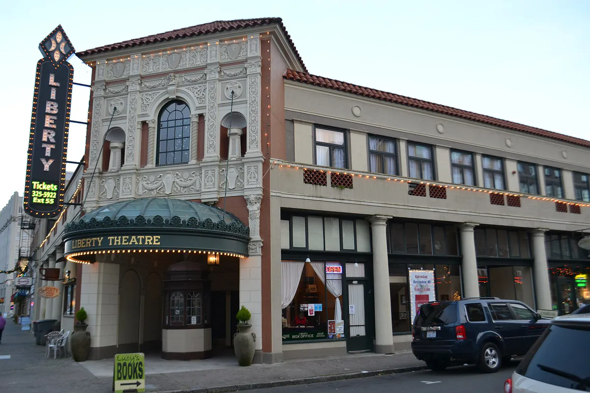
The commercial core centered along Commercial, Duane, and Exchange Streets. Offers 1920s architecture, craft breweries, the Liberty Theatre, and direct Riverwalk connections.
Best for: Maritime access, waterfront dining, and lodging near US 101
Located at Astoria's western gateway under the Astoria–Megler Bridge. Features the West Mooring Basin, Port offices, and historic working-class cannery heritage.
Best for: Historic cannery landmarks, quiet eastern waterfront, and river views
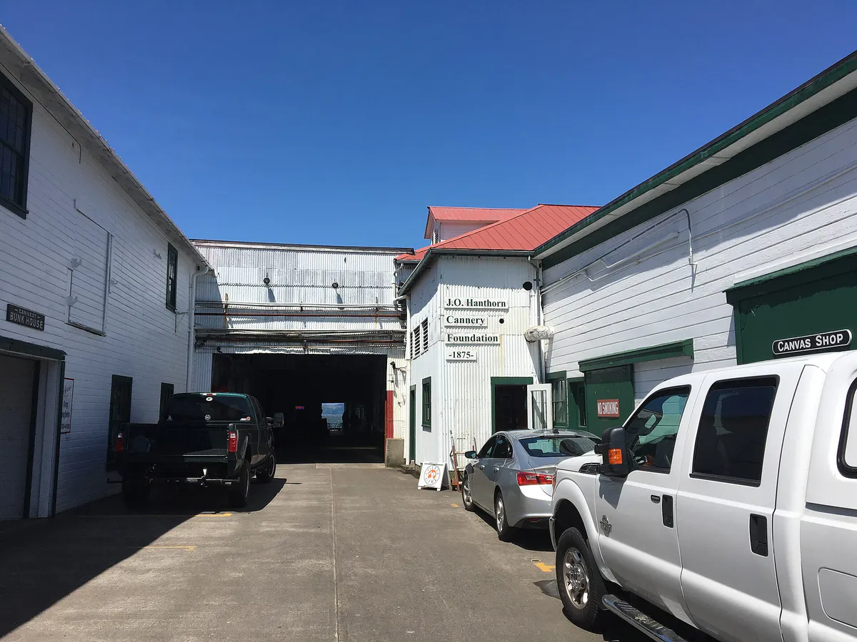
Extends along US 30 toward Tongue Point. Home to Pier 39, the historic 1875 Hanthorn Cannery, East End Mooring Basin, and local dining.
Best for: Modern residential living and peaceful walking paths
A master-planned mixed-use neighborhood built around a remediated 3.7-acre mill pond between Marine Drive and the river, offering pedestrian access close to downtown.
Best for: Panoramic estuary views, Victorian architecture, and stair climbs
Steep residential streets rising up Coxcomb Hill above downtown. Features Queen Anne homes, public stairways, Cathedral Tree Trail access, and the Astoria Column.
Best for: Residential neighborhoods removed from tourist traffic
Slopes downward toward Youngs Bay and Youngs River on the southern side of Coxcomb ridge, offering mid-range housing, school access, and local living.
Best for: Flat waterfront walks, quiet park space, and eastern river access
A quiet residential area at the far eastern end of the city. Features flat terrain, Alderbrook Park, and the eastern terminus of the Astoria Riverwalk.
Explore your options
Essential operational details for moving around Astoria by vehicle, foot, trolley, or transit.
A historic streetcar running 3 miles along the waterfront between Basin Street in Uniontown and 39th Street in Uppertown.
Managing vehicle parking across commercial, municipal, and historic sites.
Navigating highway connections and Clatsop County transit options.
Practical local guidance
Astoria experiences a cool maritime climate (Köppen Csb) heavily influenced by the Pacific Ocean and Columbia River. Keep these factors in mind when preparing for trip activities:
A simpler way to decide
Follow these practical steps to structure a smooth, stress-free day visiting Astoria.
Verify current weather conditions on arrival morning; if rain is occurring, plan indoor museum stops as the streetcar will not operate.
Park along downtown metered streets on weekdays or utilize municipal lots near City Hall after hours and on weekends.
If planning to eat at Bowpicker Fish & Chips, arrive before noon to line up for beer-battered albacore tuna before daily supplies sell out.
Allocate 2 to 3 hours to tour the Columbia River Maritime Museum, Flavel House, or the Oregon Film Museum in the historic jail.
Drive up Coxcomb Drive, purchase a $5 vehicle pass, buy a $1 balsa glider at the gift shop, and climb the 164 steps to launch it from the top.
Common local questions
These are common situations people face when trying to decide where to eat, what to do, where to get drinks, or how to spend their time in Astoria.
Astoria planning questions
Practical answers for people deciding where to eat, what to do, where to go, or how to make plans in Astoria.
Parking at Coxcomb Hill Park requires a $5 per vehicle permit, which remains valid for the rest of the calendar year. Park entry itself is free.
The trolley typically operates from late March through October, operating afternoon hours Thursday through Monday (with Tuesdays added in mid-summer) and extended weekend hours. Service does not run during rain.
Downtown street parking is metered Monday through Friday ($1.50/hr). Street parking is free on Saturdays, Sundays, and official city holidays.
Bowpicker operates out of a converted gillnetter boat until their daily albacore tuna supply is gone. If they sell out, head to nearby brewpubs like Fort George, Buoy Beer taproom, or Astoria Brewing Company along the Riverwalk.
The Astoria Riverwalk (Columbia River Trail) offers a flat, paved multi-use path stretching over 5 miles along the waterfront from Pier 3 in Uniontown to Alderbrook in the east.
Yes, regional transit connection to Portland is provided via the POINT bus network and the NW Connector system departing from the Astoria Transit Center at 9th and Astor Streets.
Pier 39 in Uppertown houses the historic 1875 Hanthorn Cannery structure, which now features dining, coffee, and museum exhibits.
No, the 4.1-mile bridge carries two narrow vehicle lanes without pedestrian sidewalks or full shoulders. Pedestrians are only permitted on the bridge during the annual Great Columbia Crossing 10K in October.
The Oregon Film Museum is located in downtown Astoria at 732 Duane Street, housed inside the historic 1914 Clatsop County Jail featured in the movie The Goonies.
Source transparency
Official and locally relevant sources used to verify the practical information presented in this Astoria decision guide.
Astoria decision engine
Tell Adventria what kind of experience you want, set your practical limits, and turn the options in Astoria into one workable plan.
Choose a Astoria Plan